Perdeu a senha?
Novo usuário? Criar uma conta
Aprecie e contribua!
| Achar os melhores spots |
|
|
 Anguilla
América Central
Trade Wind. East in summer and North East in Winter.
Localização: Caribbean, islands between the Caribbean Sea and North Atlantic Ocean, east of Puerto Rico
Coordenadas geográficas: 18° 15' N, 63° 10' W
Costa: 61 km km
Clima: tropical; moderated by northeast trade winds
Relevo: flat and low-lying island of coral and limestone
Cimeiras: lowest point: Caribbean Sea 0 m
highest point: Crocus Hill 65 m
Riscos naturais: frequent hurricanes and other tropical storms (July to October)
Moeda: East Caribbean dollar (XCD)
População: 13,677 (July 2007 est.)
Línguas: English (official)
Capital: The Valley
Divisão administrativa: none (overseas territory of the UK)
Mais informações
| Jan | Feb | Mar | Apr | May | Jun | Jul | Aug | Sep | Oct | Nov | Dec | |
|---|---|---|---|---|---|---|---|---|---|---|---|---|
| Climate | ||||||||||||
| Air temp. | ||||||||||||
| Water temp. | ||||||||||||
| Wind consistancy | ||||||||||||
| Wind force | ||||||||||||
| Best season | ||||||||||||
Você quer acrescentar outras informações sobre Anguilla? Diga-nos...
Este mapa é interactivo! Use os controles para fazer zoom ou para se deslocar.
- secções (0)
- viagens (0)
- Fotos (1)
- Vídeos (0)
- Compartilhe
- Favoritos
-
Os seus sítios favoritos e as futuras listas de spots
Spots
 Comentários
Erros, Reacções
Se você quer adicionar novas informações ou se você encontrou erros nesta página, Envie as suas observações
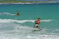
De thierry dehove , 13-12-2008
- Anguilla has 30 beaches and amazing kitesurfing spots. I ridded most of the time between Cove Bay and Savannah with East wind.. somtimes in Meads Bay and Long bay with North wind.