Perdeu a senha?
Novo usuário? Criar uma conta
Aprecie e contribua!
| Achar os melhores spots |
|
|
 Martinique
América Central
Localização: Caribbean, island between the Caribbean Sea and North Atlantic Ocean, north of Trinidad and Tobago
Coordenadas geográficas: 14° 24' N, 61° 0' W
Costa: 350 km km
Clima: tropical; moderated by trade winds; rainy season (June to October); vulnerable to devastating cyclones (hurricanes) every eight years on average; average temperature 17.3 degrees C; humid
Relevo: the island is dominated by Mount Pelee, which on 8 May 1902 erupted and completely destroyed the city of Saint Pierre, killing 30,000 inhabitants
Cimeiras: highest point: Montagne Pelee 1,397 m
Riscos naturais: hurricanes, flooding, and volcanic activity (an average of one major natural disaster every five years)
Moeda: euro (EUR)
População: 429,510 (July 2004 est.)
Línguas: French, Creole patois
Capital: Fort-de-France
Divisão administrativa: none (overseas department of France)
Você quer acrescentar outras informações sobre Martinique? Diga-nos...
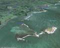
Este mapa é interactivo! Use os controles para fazer zoom ou para se deslocar.
- secções (0)
- viagens (0)
- Fotos (9)
- Vídeos (0)
- Compartilhe
- Favoritos
-
Os seus sítios favoritos e as futuras listas de spots
Spots
| Spots (2) | Qualidade | Experiência | Tipo | Acomodações | ||
|---|---|---|---|---|---|---|
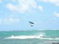
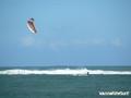
| Luciole | 4 / - | Confirmados | Lagoa | |||
| Pointe Faula | 5 / - | Todos | Lagoa | 


|
 Comentários
Erros, Reacções
Se você quer adicionar novas informações ou se você encontrou erros nesta página, Envie as suas observações